A closer look at Europe with a limited budget? Be Backpacker
Finally, after waiting for how long to travel to Europe I was able to get a visa for a walk to several countries in Western Europe as a backpacker . His name also travel abroad, because it related to the affairs of the complete document and not a little cost, then it was my plan prepared by a very mature several months before, especially about the budget, because I pay for this trip of his own savings work for the last 2 years .
This trip is not only a physical journey alone, but meets an obsession to be a tour not only perform standard activities as sweet a busy tourist taking pictures of the program and rely on travel agents, but I wish I had an exciting experience to know the culture and interact with local people and backpacker from other countries.
For visa alone is time consuming and need a strategy, especially after the terrorist issue since 2003, several countries joined the Schengen, to tighten visa requirements for filing. For the backpacker who dream to walk the few countries in Western Europe, with limited funds, must be clever, good at reading the conditions defined so that our visa application was not rejected. Previously, I was busy surfing the Internet to obtain data that a youth hostel cheap, safe and convenient access without the need for transportation as well as transportation and accommodation there. I chose the first state visit to the Netherlands because my visa at the embassy is in my opinion not ribet procedure and takes a long time. After being interviewed when entering the visa application and requirements, and waited for 8 days, finally I was happy to see the Schengen visa from the Kingdom of the Netherlands was in my passport 7 pages. Satisfied, because I take care of myself these visa applications.
Dutch
Dated May 19 I'm leaving at 18:45 from Cengkareng Airport with KLM-810 flight to Schipol. This flight takes about 13 hours with a 2-hour transit at Kuala Lumpur Airport (compared with Sukarno Hatta airport, although both countries in southeast Asia, but the KL International Airport is much more clean, modern and comfortable), luckily, from Kuala Lumpur sitting pretty beside me a man from New Zealand who became a traveling companion on the plane, so the rest of the next 10 hours is not so boring. My companion was practically flying nearly half the world, just imagine, if you count - count he have to travel from New Zealand to Dublin, Ireland for 24 hours to transit the airport 3! From him I also get valuable feedback about the super Schipol Airport and the city of Amsterdam.
The first set foot in Schipol Airport after immigration, I got confused because terbingung, my elementary school friends had been promised to pick up did not arise because there are important purposes, I was forced to ask local people how to reach accommodations that I have a message through the website international hostel reservations services. While all information / signs and street names written in Dutch, but fortunately we do not need to speak Dutch in here, because most people can speak and understand English. The airport is building a modern, clean and has great facilities. At Schipol Airport Musée du louvreoodbisa we get information tourist attractions in the Netherlands with a service professional and friendly and without exiting the building we can get a train to some town in the Netherlands.
From Schipol I boarded the train with a ticket for 3.60 euros to Amsterdam Centraal for 30 minutes. In front of Amsterdam Centraal Amsterdam is a small building Tourism & Convention Board, better known by vvv, where the tourist / traveler get more information about tourist attractions in Amsterdam and several surrounding cities, accommodation, accommodation, transport and tourism and transport tickets. By entering a 2-euro coin in the machine, we can get a map of Amsterdam. Actually if I was smart enough to read the map, do not need to bother to find the Youth Hostel which I headed. Youth Hostel there even in the midst of the city of Amsterdam, and can walk about 10 minutes from Central station, but because I have not been good at reading maps and less know the city, as a result I had to ride the metro and the money reached 1.60 euros, up and down Way down in NZ Voorburgwal, in the middle of the cold-rinrik rain with temperatures 9 degrees Celsius, and stopped at the coffee shop (Applenya Pie is really nice and not too expensive, only 2 euros) at the corner of the road NZ Voorburgwal.
The first day of my plan was like a tourist who went to the Netherlands, was the visit to Keukenhof to see the expanse of colorful tulips bloom is located not far from Delft who according to the handbook is to tour Europe's most beautiful parks in Europe. But unfortunately, according to a female officer in the Tourism Information Center Building Amsterdam Keukenhof was closed on May 19. To cover up my disappointment, I decided to go to Volendam (fishing village in the Netherlands). By pocketed round-trip ticket for Ariva-Waterland 6 euros which I bought in vvv, I take the bus number 118 that Ariva parked not far from Central Amstermdam
towards Volendam. Volendam is a beautiful fishing town with a population the majority of devout Christians. I got there at about 10:00 in the morning and most of the shops / restaurant along the beach was closed because people rushed to go to church for Mass on Sunday. Among these stores are offering Photo Studio tourists perpetuate their visit to Volendam in Volendam wearing traditional clothes. Dutch actually have some traditional clothes, but perhaps the most famous and typical Dutch regional dress Volendam is a Dutch government after it won the dress competition and traditional clothes made Dutch trade marks. In front of / in the studio glass showcase displaying all the pictures of famous people who have posed in their studios, among others, actor or sportsman photos Dutch and Europe, and a proud, perhaps because many foreign tourists from visiting Indonesia is always this coastal area, They also exhibit many Indonesian celebrity photos (that I could remember Marisa Haque, Trisha, Meli Manuhutu, Tamara Blezinsky, Rima Melati, even former President Gus Dur), it seems the way they were quite successful campaign to invite tourists from Indonesia, while I was standing in one photo studio, I heard an Indonesian tourist who insisted his friend just wanted to be photographed at Studio Gus Dur had posed. I just imagine you smiling they should examine carefully the size of the photos to find the 5 R Wahid faces in traditional clothing Volendam packaging.
Volendam had much to feel something is missing if not crossed over to Marken, a small island opposite the fishing village Volendam. In front of ticket ferry, from a distance of 5 meters I've heard the cries of my grandfather in several languages (English, Italian, French, Spanish, German and Dutch of course) invites tourists to take a ferry to Marken. Ferry Ships that crossed into Marken everything we owned and managed by local fishermen and their children. In Marken we can visit souvenir shops and restaurants hereditary have been around for a hundred years ago. Here we are also able to taste the catch of fishermen, in the form of tuna, shrimp, crabs and others with prices ranging from 2 to 4 euros per one small portion.
From Marken after browsing NZ Voorburgwal street from Amsterdam Centraal me rest awhile in Dam Square. Some tourists teenager who just got off the busy station pulled his suitcase with books Lonely Planet: Europe on the hand. In this plaza all the tourists enjoy a sunny afternoon in spring a few people busy taking a photo of himself and photos of buildings, Museums and Churches around the Dam Square, a few cool people to feed hundreds of pigeons and partly to see the action that senirupawan act like a statue waiting Nostradamus wearing people - people passing on the Dam square gives the coin 2 or 5 euros. Want pictures side by side with U2 lead singer Bono or Elvys Presley with costs 17.5 euros? On one side
Dam Square stood Madame Tussaud Museum which is famous for its wax statue of the world celebrities. So after being in a long queue, a few minutes later I was busy looking at the statues of world leaders, queen and king, and the other world celebrities from the arts, music and sports. Statue of Robin William's British singer George Clooney and Bono (U2 lead singer Music Group), Julia Robert, Lady Diana and Elvys Presley sucking enough interest and more visitors to take pictures with my visitors style that is not less exciting. It's just that before I could photograph together with famous people, we have exciting experience.
Before seeing the sculptures handsome and beautiful, in the beginning there were parts that describe the history of the establishment of an atmosphere of Amsterdam with a blurred, dark and scary, and more frightening when suddenly a large figure of a man with blood stained clothes and faces scary roar aloud, with hands that try to touch the guests. Spontaneous many visitors who screamed in terror, including myself, running quickly left the room. Apparently, the attraction is the museum manager attempts to provide a different experience to its visitors, but also demonstrated the process of making wax.
Out of Madame Tussaud was 18:30 hours and the sky Amsterdam in the spring was still light. I decided to follow the road around Amsterdam on foot through the University of Amsterdam on the famous area in Amsterdam, Red Light (original name of this street is Nieuwendijk), originally the hell I want to withdraw my intention here because the aura somewhat "scary" for people I'm innocent, let alone when I started to step toward Red Light District and past several guards restaurant or store big sex with greasy-looking coat mencekamkan plus more because by the time I was there was the roar of police cars. Well, I was going to turn around and go back to a place to stay through the University of Amsterdam and Dam Square, but I think, than the curious, I remain indifferent to it. Quite sad passing scene of young women scantily clad and beautiful on display in glass windows along the alley at the Red Light. In the shops visited by tourists in the surrounding region in addition to t-shirts that read Amsterdam, the other trinkets (bags, hats, etc.) bearing Amsterdam or marijuana leaves pictures and of course also sold dried marijuana and cannabis with a variety of quality wrapped in transparent plastic. It was not unusual to see compactor sipping cool marijuana freely on the street, the Dutch government is to give legality to them. What a country! Also here a lot of services and manufacturing tattoo piercing.
The next day I decided to fulfill my other obsession, enjoying one of the painters painting my idol, adherents impressionisme flow - more precisely pointilisme's flow-van Gogh. I remember I was so impressed with the paintings painter whose full name was Vincent van Gogh, when I first knew him from the lessons of Fine Arts in junior high school. Because of its location far enough away from Dam Square, I had to take Metro to the
there. It was true also in the employee suggestion Tourism Information Center yesterday, much better if I had bought the tickets there, so no need to wait in a long queue in front of the Van Gogh Museum. I was in a queue of visitors with a ticket that is not too long, whereas in my hand to those who queue to buy tickets at the Museum. Exactly 10 hours of opening the museum entrance, security guards with green uniforms and the uniforms striking black suit in the museum was ready mode with handi talkienya. Security guard at the museum is very tight, after passing the entrance examination, bag or jacket should be placed in the care that kept local teenagers, to capture the paintings of Van Gogh was strictly forbidden, if not uniform black suits will reprimand us .
I am amazed by Vincent van Gogh Foundation, which manages the museum is a professional, including the presentation of a collection of very interesting paintings. This may occur because they are also working with a large bank in the Netherlands to fund their programs. If the Indonesian government can do the same thing, attracting tourists and residents of Indonesia to visit the museum ...
Managers exhibit paintings in a few decades of Van Gogh's life, writing a series featuring Van Gogh's life since she was small, the school at the seminary until he switched his career as a painter began by working as a beginner at some offices in Belgium and France. Want to know the journey of life and works of Van Gogh? There was one particular room that contained many books, and also if we are tired around the building and up the stairs 4-storey building, we can see in the computer museum collections provided in this room. In this room we also teach how to make paintings like the Van Gogh, for example, explained how and materials to create a basic canvas before starting to paint, the difference with the Van Gogh painting painter painting Pointilisme flow in the same era with him. Out of the exit, there are souvenir shops that sell post cards, books, bookmark and even a large poster of Van Gogh paintings reproduction.
Brussels, Belgium
The next day I decided to melanglang into neighboring countries, Brussels, Belgium. Brussels is a city that is not too large. Most of the population communicate in Dutch and French, so I had to bring my French dictionary pocket wherever I go. After previously booked a room at the Center Vincent Van Gogh (Youth Hostel) is located at 8 Rue Traversiere in http://www.hostelworld.com, so I boarded the train from Amsterdam Central to Brussels Midi in the ticket price of 33.4 euros. Hostel devoted young children under the age of 35 years used to be the kind of apartment where Van Gogh once lived, is located not far from Le jardin Botanique (Botanique Park). Hostel which is this old building, run by young kids so obviously teenage atmosphere. In the lobby of all backpacker from various countries could become acquainted and talk about their journey, drinking beer or other drinks, surf the Internet, or billiard playing in the middle of the living room with rock music that echoed the room is not too broad. Lobby is getting crowded after 6 pm, because that's when the cafe opened.
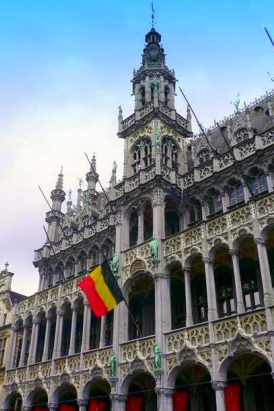
Not many attractions that can be visited in Brussels. The first day I walked into Le Jardin Botanique, Grand Place, and the Museum Smurf Comics. Le Botanique is a city park decorated with ornamental plants and colorful water pools and bronze statues that had been there since the Middle Ages. At that time I saw a group of small children of men who shouted play football cool, young couple is making love couple, tourists were posing for the camera and pedestrians through the park happier than they have to pass the sidewalk. From the park I went on the streets during the Grand Place, past the Super City Mall and several buildings of Baroque-style city. Prior to the Grand Place, I pass a hallway full of cafes and restaurants Greece, Italy and Morocco. Restaurant waiters who looked lovely with a clean white dress or a suit calling the pedestrians to stop by their restaurant. It's just that I had my stomach fill with kebabs that I bought at small shops owned by Turks near the Mall. Grand Place is not too different from the Dam Square, in here people gathered both locals and tourists to admire the old buildings with beautiful architecture.
If France has the Eiffel Tower, Italy Tower of Pisa is famous for, then Belgium has Atomium. So on the second day before I left Brussels, I decided to go to Belgium this land mark. Because of its location far enough away from the hostel where I stayed, I had to take Metro Line 1 A is stopped at the Heysel Bus Station. Compared with the two towers that I mentioned earlier, this Atomium building is still very young relative, as newly built in 1958 and renovated in 2003 and not too high, the height from the ground until the ball reaches the highest 102 meters .. As the name implies, Atomium is a giant metal ball 9 diameter of 18 meters each connected / supported with metal. Each - each ball has a specific function, such as on the ball besides Perama where visitors buy tickets in the show is also a permanent place, at saatitu exhibited munggil cars with bright colors like candy. Visitors can reach the highest ball through the elevator after buying tickets for 7 euros. At this highest sphere we can see the scene below through a screen-like computer, or if you want a romantic atmosphere with a taste of typical Belgian food, could drop the ball on the top floor is the "Panorama Restaurant". Want to visit and know better the European in minutes? Not far from the Atomium are other attractions that are not less interesting, Thumbnail Europe. Here we get to know the countries in Europe through a miniature landmarks of each country. Unfortunately I have reached in his wallet again to see these mini Europe.
Finally, after waiting for how long to travel to Europe I was able to get a visa for a walk to several countries in Western Europe as a backpacker
. His name also travel abroad, because it related to the affairs of the complete document and not a little cost, then it was my plan prepared by a very mature several months before, especially about the budget, because I pay for this trip of his own savings work for the last 2 years . This trip is not only a physical journey alone, but meets an obsession to be a tour not only perform standard activities as sweet a busy tourist taking pictures of the program and rely on travel agents, but I wish I had an exciting experience to know the culture and interact with local people and backpacker from other countries.
For visa alone is time consuming and need a strategy, especially after the terrorist issue since 2003, several countries joined the Schengen, to tighten visa requirements for filing. For the backpacker who dream to walk the few countries in Western Europe, with limited funds, must be clever, good at reading the conditions defined so that our visa application was not rejected. Previously, I was busy surfing the Internet to obtain data that a youth hostel cheap, safe and convenient access without the need for transportation as well as transportation and accommodation there. I chose the first state visit to the Netherlands because my visa at the embassy is in my opinion not ribet procedure and takes a long time. After being interviewed when entering the visa application and requirements, and waited for 8 days, finally I was happy to see the Schengen visa from the Kingdom of the Netherlands was in my passport 7 pages. Satisfied, because I take care of myself these visa applications.
Dutch
Dated May 19 I'm leaving at 18:45 from Cengkareng Airport with KLM-810 flight to Schipol. This flight takes about 13 hours with a 2-hour transit at Kuala Lumpur Airport (compared with Sukarno Hatta airport, although both countries in southeast Asia, but the KL International Airport is much more clean, modern and comfortable), luckily, from Kuala Lumpur sitting pretty beside me a man from New Zealand who became a traveling companion on the plane, so the rest of the next 10 hours is not so boring. My companion was practically flying nearly half the world, just imagine, if you count - count he have to travel from New Zealand to Dublin, Ireland for 24 hours to transit the airport 3! From him I also get valuable feedback about the super Schipol Airport and the city of Amsterdam.
The first set foot in Schipol Airport after immigration, I got confused because terbingung, my elementary school friends had been promised to pick up did not arise because there are important purposes, I was forced to ask local people how to reach accommodations that I have a message through the website international hostel reservations services. While all information / signs and street names written in Dutch, but fortunately we do not need to speak Dutch in here, because most people can speak and understand English. The airport is building a modern, clean and has great facilities. At Schipol Airport Musée du louvreoodbisa we get information tourist attractions in the Netherlands with a service professional and friendly and without exiting the building we can get a train to some town in the Netherlands.
From Schipol I boarded the train with a ticket for 3.60 euros to Amsterdam Centraal for 30 minutes. In front of Amsterdam Centraal Amsterdam is a small building Tourism & Convention Board, better known by vvv, where the tourist / traveler get more information about tourist attractions in Amsterdam and several surrounding cities, accommodation, accommodation, transport and tourism and transport tickets. By entering a 2-euro coin in the machine, we can get a map of Amsterdam. Actually if I was smart enough to read the map, do not need to bother to find the Youth Hostel which I headed. Youth Hostel there even in the midst of the city of Amsterdam, and can walk about 10 minutes from Central station, but because I have not been good at reading maps and less know the city, as a result I had to ride the metro and the money reached 1.60 euros, up and down Way down in NZ Voorburgwal, in the middle of the cold-rinrik rain with temperatures 9 degrees Celsius, and stopped at the coffee shop (Applenya Pie is really nice and not too expensive, only 2 euros) at the corner of the road NZ Voorburgwal.
The first day of my plan was like a tourist who went to the Netherlands, was the visit to Keukenhof to see the expanse of colorful tulips bloom is located not far from Delft who according to the handbook is to tour Europe's most beautiful parks in Europe. But unfortunately, according to a female officer in the Tourism Information Center Building Amsterdam Keukenhof was closed on May 19. To cover up my disappointment, I decided to go to Volendam (fishing village in the Netherlands). By pocketed round-trip ticket for Ariva-Waterland 6 euros which I bought in vvv, I take the bus number 118 that Ariva parked not far from Central Amstermdam
towards Volendam. Volendam is a beautiful fishing town with a population the majority of devout Christians. I got there at about 10:00 in the morning and most of the shops / restaurant along the beach was closed because people rushed to go to church for Mass on Sunday. Among these stores are offering Photo Studio tourists perpetuate their visit to Volendam in Volendam wearing traditional clothes. Dutch actually have some traditional clothes, but perhaps the most famous and typical Dutch regional dress Volendam is a Dutch government after it won the dress competition and traditional clothes made Dutch trade marks. In front of / in the studio glass showcase displaying all the pictures of famous people who have posed in their studios, among others, actor or sportsman photos Dutch and Europe, and a proud, perhaps because many foreign tourists from visiting Indonesia is always this coastal area, They also exhibit many Indonesian celebrity photos (that I could remember Marisa Haque, Trisha, Meli Manuhutu, Tamara Blezinsky, Rima Melati, even former President Gus Dur), it seems the way they were quite successful campaign to invite tourists from Indonesia, while I was standing in one photo studio, I heard an Indonesian tourist who insisted his friend just wanted to be photographed at Studio Gus Dur had posed. I just imagine you smiling they should examine carefully the size of the photos to find the 5 R Wahid faces in traditional clothing Volendam packaging.
Volendam had much to feel something is missing if not crossed over to Marken, a small island opposite the fishing village Volendam. In front of ticket ferry, from a distance of 5 meters I've heard the cries of my grandfather in several languages (English, Italian, French, Spanish, German and Dutch of course) invites tourists to take a ferry to Marken. Ferry Ships that crossed into Marken everything we owned and managed by local fishermen and their children. In Marken we can visit souvenir shops and restaurants hereditary have been around for a hundred years ago. Here we are also able to taste the catch of fishermen, in the form of tuna, shrimp, crabs and others with prices ranging from 2 to 4 euros per one small portion.
From Marken after browsing NZ Voorburgwal street from Amsterdam Centraal me rest awhile in Dam Square. Some tourists teenager who just got off the busy station pulled his suitcase with books Lonely Planet: Europe on the hand. In this plaza all the tourists enjoy a sunny afternoon in spring a few people busy taking a photo of himself and photos of buildings, Museums and Churches around the Dam Square, a few cool people to feed hundreds of pigeons and partly to see the action that senirupawan act like a statue waiting Nostradamus wearing people - people passing on the Dam square gives the coin 2 or 5 euros. Want pictures side by side with U2 lead singer Bono or Elvys Presley with costs 17.5 euros? On one side
Dam Square stood Madame Tussaud Museum which is famous for its wax statue of the world celebrities. So after being in a long queue, a few minutes later I was busy looking at the statues of world leaders, queen and king, and the other world celebrities from the arts, music and sports. Statue of Robin William's British singer George Clooney and Bono (U2 lead singer Music Group), Julia Robert, Lady Diana and Elvys Presley sucking enough interest and more visitors to take pictures with my visitors style that is not less exciting. It's just that before I could photograph together with famous people, we have exciting experience.
Before seeing the sculptures handsome and beautiful, in the beginning there were parts that describe the history of the establishment of an atmosphere of Amsterdam with a blurred, dark and scary, and more frightening when suddenly a large figure of a man with blood stained clothes and faces scary roar aloud, with hands that try to touch the guests. Spontaneous many visitors who screamed in terror, including myself, running quickly left the room. Apparently, the attraction is the museum manager attempts to provide a different experience to its visitors, but also demonstrated the process of making wax.
Out of Madame Tussaud was 18:30 hours and the sky Amsterdam in the spring was still light. I decided to follow the road around Amsterdam on foot through the University of Amsterdam on the famous area in Amsterdam, Red Light (original name of this street is Nieuwendijk), originally the hell I want to withdraw my intention here because the aura somewhat "scary" for people I'm innocent, let alone when I started to step toward Red Light District and past several guards restaurant or store big sex with greasy-looking coat mencekamkan plus more because by the time I was there was the roar of police cars. Well, I was going to turn around and go back to a place to stay through the University of Amsterdam and Dam Square, but I think, than the curious, I remain indifferent to it. Quite sad passing scene of young women scantily clad and beautiful on display in glass windows along the alley at the Red Light. In the shops visited by tourists in the surrounding region in addition to t-shirts that read Amsterdam, the other trinkets (bags, hats, etc.) bearing Amsterdam or marijuana leaves pictures and of course also sold dried marijuana and cannabis with a variety of quality wrapped in transparent plastic. It was not unusual to see compactor sipping cool marijuana freely on the street, the Dutch government is to give legality to them. What a country! Also here a lot of services and manufacturing tattoo piercing.
The next day I decided to fulfill my other obsession, enjoying one of the painters painting my idol, adherents impressionisme flow - more precisely pointilisme's flow-van Gogh. I remember I was so impressed with the paintings painter whose full name was Vincent van Gogh, when I first knew him from the lessons of Fine Arts in junior high school. Because of its location far enough away from Dam Square, I had to take Metro to the
there. It was true also in the employee suggestion Tourism Information Center yesterday, much better if I had bought the tickets there, so no need to wait in a long queue in front of the Van Gogh Museum. I was in a queue of visitors with a ticket that is not too long, whereas in my hand to those who queue to buy tickets at the Museum. Exactly 10 hours of opening the museum entrance, security guards with green uniforms and the uniforms striking black suit in the museum was ready mode with handi talkienya. Security guard at the museum is very tight, after passing the entrance examination, bag or jacket should be placed in the care that kept local teenagers, to capture the paintings of Van Gogh was strictly forbidden, if not uniform black suits will reprimand us .
I am amazed by Vincent van Gogh Foundation, which manages the museum is a professional, including the presentation of a collection of very interesting paintings. This may occur because they are also working with a large bank in the Netherlands to fund their programs. If the Indonesian government can do the same thing, attracting tourists and residents of Indonesia to visit the museum ...
Managers exhibit paintings in a few decades of Van Gogh's life, writing a series featuring Van Gogh's life since she was small, the school at the seminary until he switched his career as a painter began by working as a beginner at some offices in Belgium and France. Want to know the journey of life and works of Van Gogh? There was one particular room that contained many books, and also if we are tired around the building and up the stairs 4-storey building, we can see in the computer museum collections provided in this room. In this room we also teach how to make paintings like the Van Gogh, for example, explained how and materials to create a basic canvas before starting to paint, the difference with the Van Gogh painting painter painting Pointilisme flow in the same era with him. Out of the exit, there are souvenir shops that sell post cards, books, bookmark and even a large poster of Van Gogh paintings reproduction.
Brussels, Belgium
The next day I decided to melanglang into neighboring countries, Brussels, Belgium. Brussels is a city that is not too large. Most of the population communicate in Dutch and French, so I had to bring my French dictionary pocket wherever I go. After previously booked a room at the Center Vincent Van Gogh (Youth Hostel) is located at 8 Rue Traversiere in http://www.hostelworld.com, so I boarded the train from Amsterdam Central to Brussels Midi in the ticket price of 33.4 euros. Hostel devoted young children under the age of 35 years used to be the kind of apartment where Van Gogh once lived, is located not far from Le jardin Botanique (Botanique Park). Hostel which is this old building, run by young kids so obviously teenage atmosphere. In the lobby of all backpacker from various countries could become acquainted and talk about their journey, drinking beer or other drinks, surf the Internet, or billiard playing in the middle of the living room with rock music that echoed the room is not too broad. Lobby is getting crowded after 6 pm, because that's when the cafe opened.
Not many attractions that can be visited in Brussels. The first day I walked into Le Jardin Botanique, Grand Place, and the Museum Smurf Comics. Le Botanique is a city park decorated with ornamental plants and colorful water pools and bronze statues that had been there since the Middle Ages. At that time I saw a group of small children of men who shouted play football cool, young couple is making love couple, tourists were posing for the camera and pedestrians through the park happier than they have to pass the sidewalk. From the park I went on the streets during the Grand Place, past the Super City Mall and several buildings of Baroque-style city. Prior to the Grand Place, I pass a hallway full of cafes and restaurants Greece, Italy and Morocco. Restaurant waiters who looked lovely with a clean white dress or a suit calling the pedestrians to stop by their restaurant. It's just that I had my stomach fill with kebabs that I bought at small shops owned by Turks near the Mall. Grand Place is not too different from the Dam Square, in here people gathered both locals and tourists to admire the old buildings with beautiful architecture.
If France has the Eiffel Tower, Italy Tower of Pisa is famous for, then Belgium has Atomium. So on the second day before I left Brussels, I decided to go to Belgium this land mark. Because of its location far enough away from the hostel where I stayed, I had to take Metro Line 1 A is stopped at the Heysel Bus Station. Compared with the two towers that I mentioned earlier, this Atomium building is still very young relative, as newly built in 1958 and renovated in 2003 and not too high, the height from the ground until the ball reaches the highest 102 meters .. As the name implies, Atomium is a giant metal ball 9 diameter of 18 meters each connected / supported with metal. Each - each ball has a specific function, such as on the ball besides Perama where visitors buy tickets in the show is also a permanent place, at saatitu exhibited munggil cars with bright colors like candy. Visitors can reach the highest ball through the elevator after buying tickets for 7 euros. At this highest sphere we can see the scene below through a screen-like computer, or if you want a romantic atmosphere with a taste of typical Belgian food, could drop the ball on the top floor is the "Panorama Restaurant". Want to visit and know better the European in minutes? Not far from the Atomium are other attractions that are not less interesting, Thumbnail Europe. Here we get to know the countries in Europe through a miniature landmarks of each country. Unfortunately I have reached in his wallet again to see these mini Europe.